Arcovian Foothills
From Guild Wars 2 Wiki
Jump to navigationJump to search
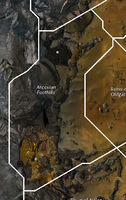
Arcovian Foothills
2
 |
- Level
- 18
- Type
- Area
- Zone
- Diessa Plateau
(Ascalon) - Connects to
- Ruins of Oldgate (E)
The Wurm's Gullet (N)
Halrunting Plains (NE)
Town of Nolan (S)
| Image(s) |
|
Click to enlarge. |
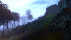
Arcovian Foothills is an area with rugged slopes that separate Ascalon from the Shiverpeak Mountains within the Diessa Plateau. To the north there is a small troop of Flame Legion at Silex Castrum.
Locations and objectives[edit]
- Points of Interest
- North Nolan Hatchery —
- Silex Castrum —
NPCs[edit]
Allies[edit]
- Zola Swiftstep (16)
Pets[edit]
Foes[edit]
- Black Bear (16)
- Lashtail Devourer (16-17)
- Lashtail Devourer Hatchling (16)
- Veteran Lashtail Devourer (17)
- Flame Legion Axe Fiend (16)
- Flame Legion Bladestorm (16)
- Flame Legion Fire Shaman (17)
- Flame Legion Lava Shaman (17)
- Flame Legion Shadowblade (16)
- Flame Legion Stalker (16)
Objects[edit]
Crafting resources[edit]
- Resource nodes
- Copper Ore
- Rich Iron Vein
- Silver Ore
Notes[edit]
- Although the North Nolan Hatchery is within the borders of this area, the hitbox to "discover" the POI is actually within the Town of Nolan, and as such is listed as present in that area rather than this area.

